CASE STUDY: BOSCASTLE FLOODS 2004
YOU WILL NEED: a pen, something to write on and a ruler.
Divide your page into 4 coloumns: 1) Background information 2) Causes 3) Social, Economic, Environmental Effects 4) Responses
As you review the below information make notes by completing your table. Make sure you use ALL the resources provided.
Divide your page into 4 coloumns: 1) Background information 2) Causes 3) Social, Economic, Environmental Effects 4) Responses
As you review the below information make notes by completing your table. Make sure you use ALL the resources provided.
THE LOWDOWN
What: Village of Boscastle was flooded by an estimated 440 million gallons of rain water.
When: 16th August 2004
Where: Boscastle is a small village on the north coast of Cornwall. It is about 10 miles south of Bude, and 10 miles west of Launceston.
Why: The confluence of two rivers (R. Valency & R. Jordan) meet just east of Boscastle; 75mm of rain fell in two hours (the same as normally falls in the whole month of August); The physical geography of the surrounding land is steep sloping hills which meant there was rapid surface run-off into the nearby rivers.
Who: Boscastle has a population of 888 (c.2001). The flood caused devastation to local families, business, road networks, harbour and tourism.
LINKS YOU SHOULD READ
BELOW ARE TWO DOCUMENTARIES SHOWING BOSCASTLE DURING THE FLOOD AND HOW IT HAS DEVELOPED 10 YEARS ON
What: Village of Boscastle was flooded by an estimated 440 million gallons of rain water.
When: 16th August 2004
Where: Boscastle is a small village on the north coast of Cornwall. It is about 10 miles south of Bude, and 10 miles west of Launceston.
Why: The confluence of two rivers (R. Valency & R. Jordan) meet just east of Boscastle; 75mm of rain fell in two hours (the same as normally falls in the whole month of August); The physical geography of the surrounding land is steep sloping hills which meant there was rapid surface run-off into the nearby rivers.
Who: Boscastle has a population of 888 (c.2001). The flood caused devastation to local families, business, road networks, harbour and tourism.
LINKS YOU SHOULD READ
- The event made national news then and 10 years on (click on the highlighted words to go to the link).
- Check out this great case study put together by the MET OFFICE. Click here.
BELOW ARE TWO DOCUMENTARIES SHOWING BOSCASTLE DURING THE FLOOD AND HOW IT HAS DEVELOPED 10 YEARS ON
|
|
|
OPEN, PRINT AND READ THE BELOW DOCUMENT
| boscastleflood.pdf |
IN REVIEW - the information below is in summary and not everything you need to know!
|
CAUSES
- The confluence of two rivers (R. Valency & R. Jordan) meet just east of Boscastle. - 75mm of rain fell in two hours (the same as normally falls in the whole month of August). - The physical geography of the surrounding land is steep sloping hills of impermeable clay and rock which meant there was rapid surface run-off into the nearby rivers. - Peak river discharge flow was at 100 cumecs at 6 pm on the day of the flood, 2 and a half hours after peak rainfall (15 mm in 30 minutes between 3pm and 3.30pm). See below image for flood hydrograph of Boscastle 2004. |
SOCIAL EFFECTS
- People's homes and businesses were destroyed by the flood. These had to be rebuilt over time. ECONOMIC EFFECTS - 90% of Boscastle's economy is dependent on tourism. The flood meant 20 hotels and B&B's had to close. - 66% of annual business is done during July and August. This was severely impacted. ENVIRONMENTAL EFFECTS - Town environment damaged by debris from flood waters. Sediment and river detritus deposited in the streets. - Cars swept downstream into the harbour area. |
RESPONSES AND 10 YEARS ON
Immediate response: - Helicopter rescue of stranded residents. -Clearing of debris and destruction. Long term response: - £4.5 million spent on flood defences. - Improved road drainage network to cope with higher flow rates. - Village bridge has been rebuilt higher and wider to prevent blockages in the event of future flash flood events. - Afforestation of surrounding hills. - Dredging of river to reduce sediment build up which would increase capacity of the river. -Rebuilding of homes and businesses. |
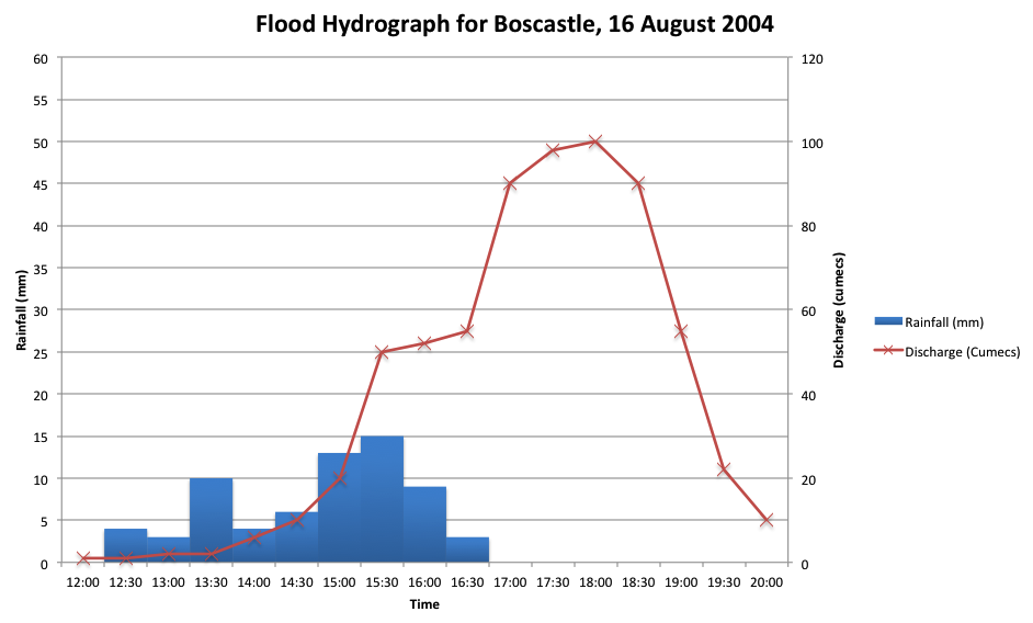
TASK: From 1200 to 2000 describe what was happening each hour in Boscastle. Refer to rainfall, river discharge and the effects on people and the environment.
Then, explain why this happened in Boscastle, suggest what the "flashy catchment" nature of the area had to do with the effects.
Then, explain why this happened in Boscastle, suggest what the "flashy catchment" nature of the area had to do with the effects.
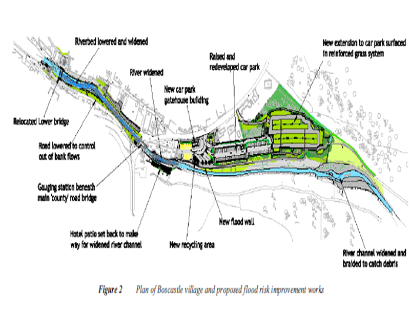
TASK: Above is a plan of Boscastle showing flood risk improvements after the 2004 flash flood. Identify 5 different measures put in place to help prevent floods devastating the village again. Then, suggest how this method will help.
CASE STUDTY QUESTION: (Revise your notes first, then complete the question. After, review your response and improve it using your notes)
For a named area you have studied, describe and explain the effects of flooding on people and the environment. (8 marks)
CASE STUDY: PAKISTAN FLOODS 2010
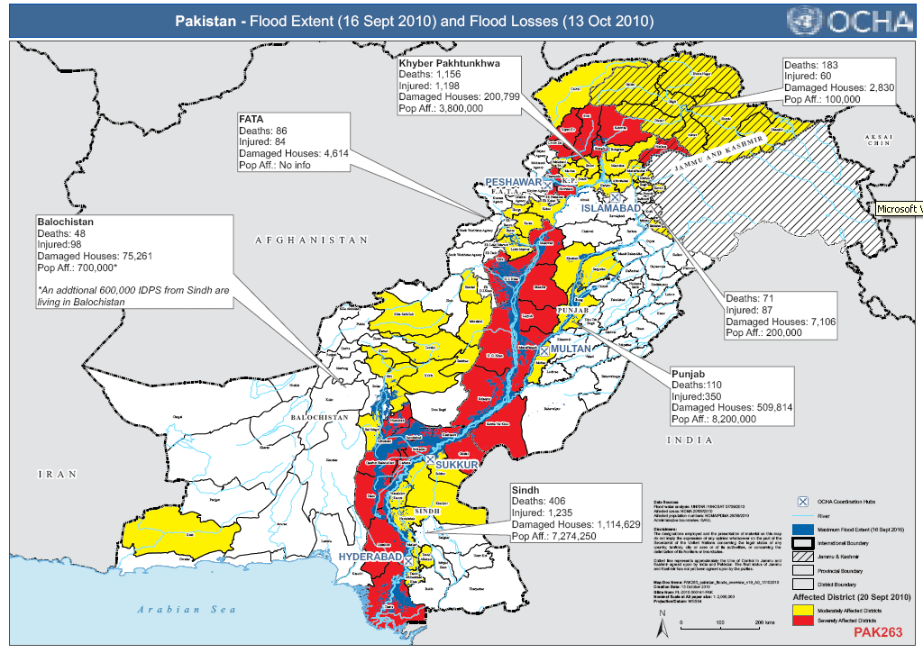
TASK: As you read/watch/listen YOU NEED TO divide your page into 3 columns - 1) Causes, 2) Effects (social, economic, environmental), 3) Responses. Use the map to describe the location and effects in places like Sindh, Punjab, Khyber Pakhtunkhwa. Where was worst affected? Why?
Read the links below adding to your causes, effects and responses.
LINKS
- UK Parliament Case Study. Click here to go to the link, read through and use the green "next" button at the foot of each page to follow causes, effects and responses to the natural disaster.
- What have OXFAM been doing? Download and read their report (it is the .pdf below) - you can read it all if you want, but the introduction will do up to page 10.
| pakistan-progress-report-floods-260711-en.pdf |
Finally, continue with your table of Causes / Effects / Responses. Watch the documentary below to help build and add to your revision notes.
CASE STUDY QUESTION: (Revise your notes first, then complete the question. After, review your response and improve it using your notes)
For a named flood you have studied in an LEDC: Name and locate the area affected. Explain the causes of the flood. Describe the effects of the flood on people and the environment.
(8 marks)
For a named flood you have studied in an LEDC: Name and locate the area affected. Explain the causes of the flood. Describe the effects of the flood on people and the environment.
(8 marks)
The Amazon
TASK
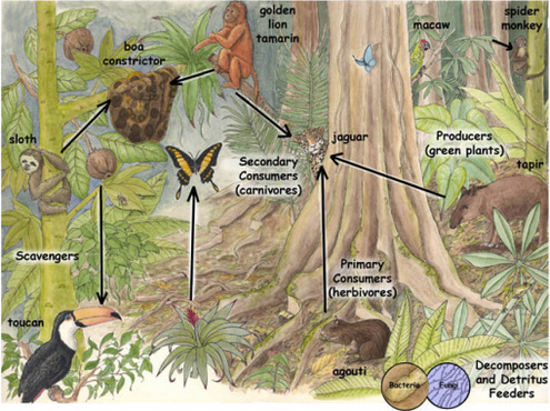
- You will need to create your own biodiversity web including: producers, primary consumers, secondary consumers, tertiary consumers and decomposers. Use the images below to help guide your food web, you should also use your notes from your exercise book and GCSEpod.
- Click on this link about the Yanomami tribe and make notes about their way of life and their latest threats.
BACKGROUND
The Amazon rainforest today covers around 5.5 million square kilometres and sprawls across nine different countries. This tropical rainforest is hot all year round with an average temperature of 27-30°C . The Amazon has a daily climate rainfall routine with an annual precipitation of 2000-3000mm.
The Amazon rainforest today covers around 5.5 million square kilometres and sprawls across nine different countries. This tropical rainforest is hot all year round with an average temperature of 27-30°C . The Amazon has a daily climate rainfall routine with an annual precipitation of 2000-3000mm.
|
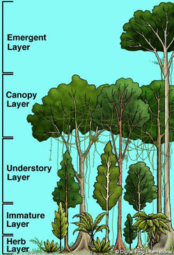
On the left, you will see a biodiversity web. This explains that living organisms depend on each other to live.
On the right, you will see the structure of the rainforest. Plants fight for space and sunlight to survive in the rainforest. |
BELOW ARE FOUR SHORT CLIPS THAT SHOW YOU DIFFERENT USES OF THE TROPICAL RAINFOREST
TASK: Describe what the uses are, and identify the positive and negative impacts these uses of the rainforest have on people and the environment.
TASK: Describe what the uses are, and identify the positive and negative impacts these uses of the rainforest have on people and the environment.
|
|
|
Yanomami
- The Yanomami tribe has lived in the Amazon rainforest for around 15,000 years.
- They are sustainable and do not harm the environment around.
- Today the Yanomami are suffering in health due to gold miners working illegally on their land.
For more information about the Yanomami tribe click here.
Plants, animals and insects are dying in the Amazon rainforest. We are only just realising the true value of this biodiverse land. Rainforests once covered 14% of the Earth's surface but now only cover a mere 6%. It is predicted that within the next 40 years, there will be no more rainforests.
One and a half acres of rainforest are lost every second with consequences for every country in the world to face. Experts estimate that we are losing 137 plant, animal and insect species everyday from rainforest destruction. As the rainforest species disappear, cures for diseases do too.
Fires, farming, bulldozers and chainsaws are all things that are tearing down our rainforests. Tribes living in the Amazon rainforest suffer from diseases unknown to them. Natural ecosystems are being disrupted. The Amazon rainforest needs to be conserved or in the future there will no longer be one.
TASK: Choose three images from the above scroll. Identify positive and negative impacts humans are having or could have on the environment.
CASE STUDY QUESTION: (Revise your notes first, then complete the question. After, review your response and improve it using your notes)
For a named economic activity you have studied in an LEDC explain how the activity is impacting on people and the environment. Describe how it is being managed to limit its impacts on the environment. (8 marks)
For a named economic activity you have studied in an LEDC explain how the activity is impacting on people and the environment. Describe how it is being managed to limit its impacts on the environment. (8 marks)
Dorset Coastline Management
You need to include:
A map of the area studied - the Dorset heritage (Jurassic) coast. Describe what your map shows below the image.
Images and description of coastal landforms at Studland Bay, Old Harry Rocks, Durdle Door, Lulworth Cove. Why are these coastal landforms not protected? Explain this.
Tourism is an important part of the economy here because of these famous coastal landforms. Explain how this would affect types of coastal management decisions.
Annotated images of coastal management methods at this location.
What different management methods are being used at Lyme Regis? And Poole Harbour? Why are these appropriate?
Add any recent news articles via a link to show changes to the coast here, or management of the coast. Search google.
Can you find any appropriate video clips about tourism along the Dorset coast? What about management methods?
Add images to show what is happening there to better develop your readers experience using this website.
Create a TASK for your user to do whilst they are reading the information about The Amazon.
